A Florida Man Used Google Earth To Unravel A 22-Year-Old Mystery
It’s hard to imagine that Google Earth was created for the purpose of solving decades-old cold cases — but that’s exactly what happened in 2019. One Florida man loaded up the software and started examining various satellite images. Then he spotted a shape in a body of water. And when he zoomed in, a shiver ran down his spine. This one discovery would lead the police to eventually fish out the object and clear a 22-year-old case from their books.
A discovery in his old neighborhood
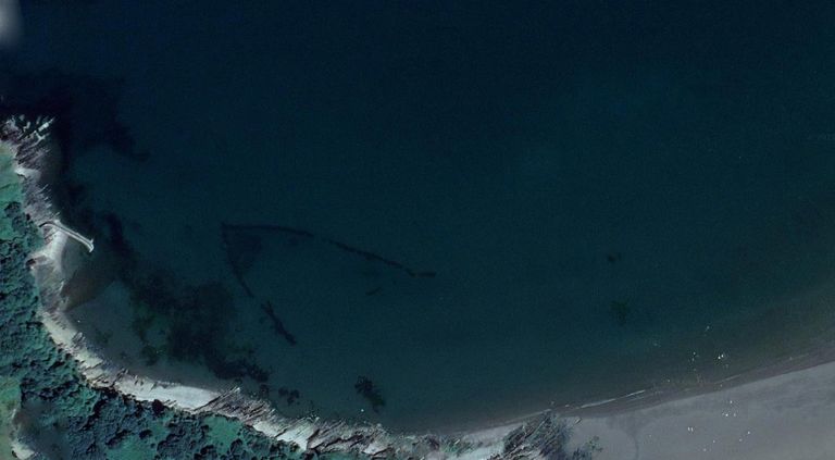
The unidentified man was a property expert who happened to be scouting out his old Florida neighborhood on Google Earth. Poking around where he used to live, he clicked on the area behind one of the houses.
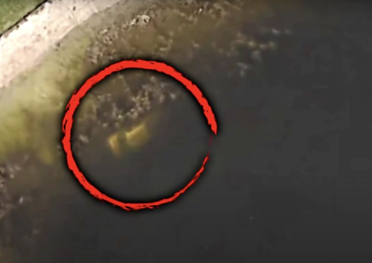
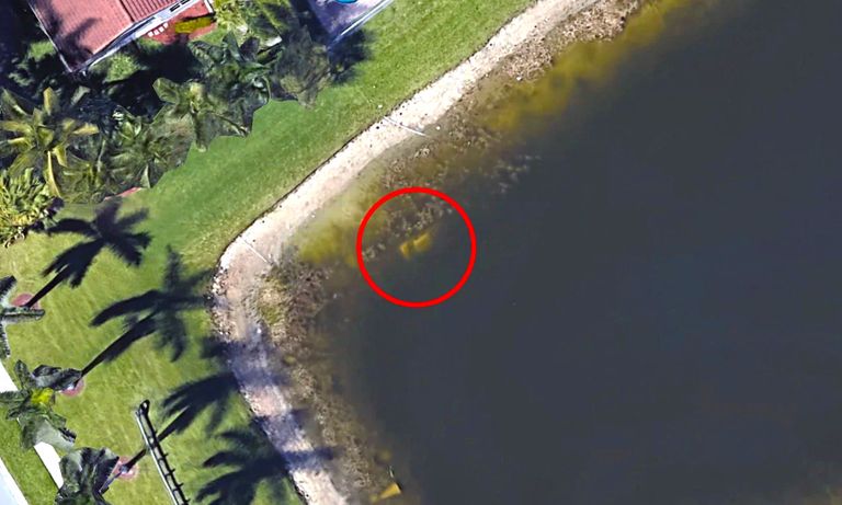
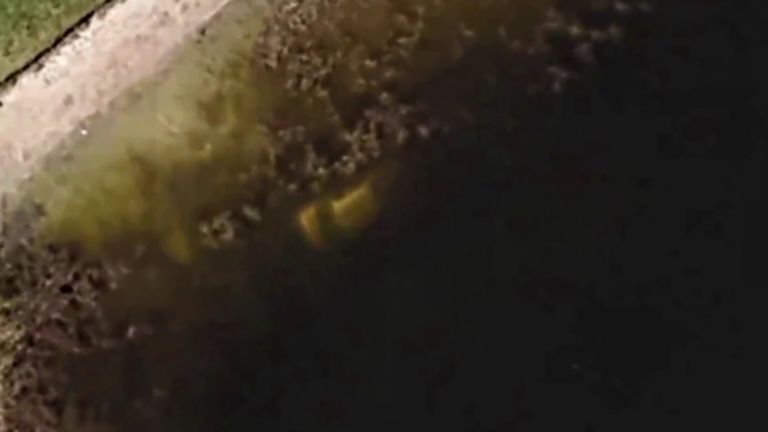
That's when he noticed something out of the ordinary: there, submerged in a pond, was what appeared to be a vehicle. Well, that’s what it looked like to the intrepid digital explorer at least.
Kick-starting the investigation
There was no way that the man could be sure exactly what he was looking at. He was, after all, just going off of a blurry image on Google Earth. But he had an idea of how he could get confirmation.
The man got in touch with his ex-wife, who reportedly still lived at his old address. According to a statement from the Palm Beach County Sheriff’s Office, the ex-wife later mentioned it to her neighbor, Barry Fay.
Taking a closer look
Fay agreed that the images on Google Earth made it look like there really was a vehicle in the pond behind his home. In September 2019 Fay told The Palm Beach Post that he went to check it out for himself.
He didn't find anything after his first look. By this time, Fay had been living in the house for over a year, and he’d apparently never seen anything to suggest that a car was submerged in the water. Fay seemingly didn't give up that easily, though.
Send in the drone
“The water’s been way low and I still never noticed anything,” Fay told The Palm Beach Post. Undeterred, he contacted another neighbor who owned a drone — the kind you can attach a camera to.
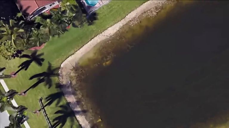
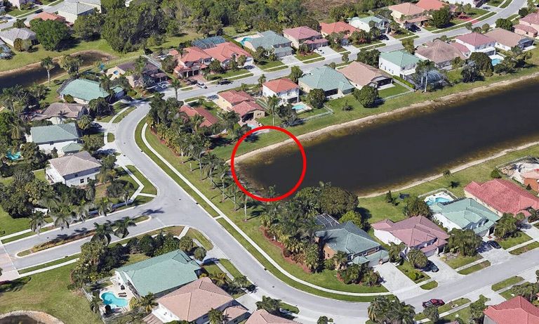
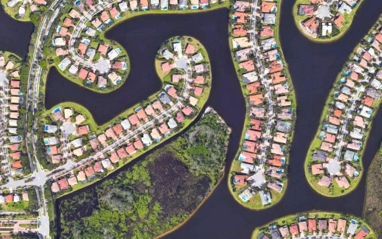
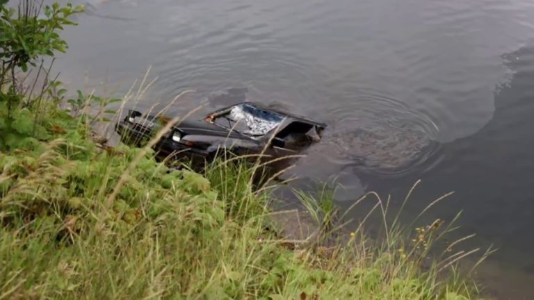
The curious pair flew the drone over the retention pond in the Grand Isles neighborhood in Wellington. It revealed, clear as anything, that there was indeed a car sitting in the murky waters.
Getting the police involved
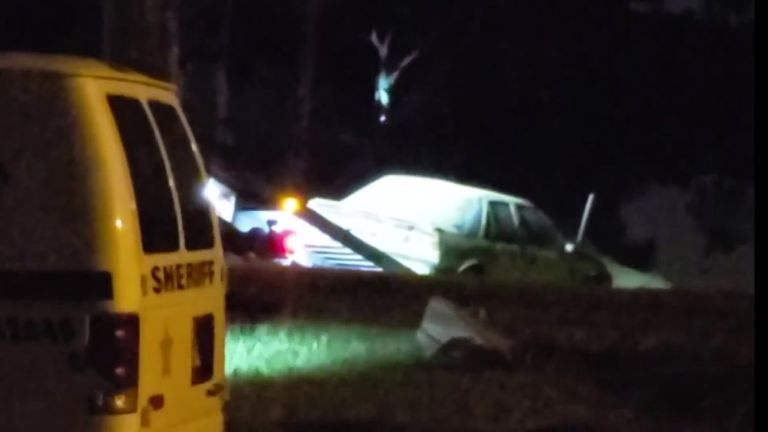
Fay and his neighbor had done all that they could. Fay contacted the local sheriff’s office right away, and the authorities subsequently arrived on the scene. This was at 6:40 p.m.

Police were working at the site for the next six hours. Fay told The Palm Beach Post, “They had my whole backyard roped off with crime-scene tape.” But the real spine-chilling discovery waited inside the vehicle.
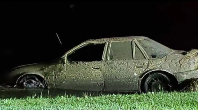
The first clue
When police lifted out the vehicle sometime after midnight, they finally had a chance to examine it. They found that it had calcified, suggesting that it had been submerged for a long time.
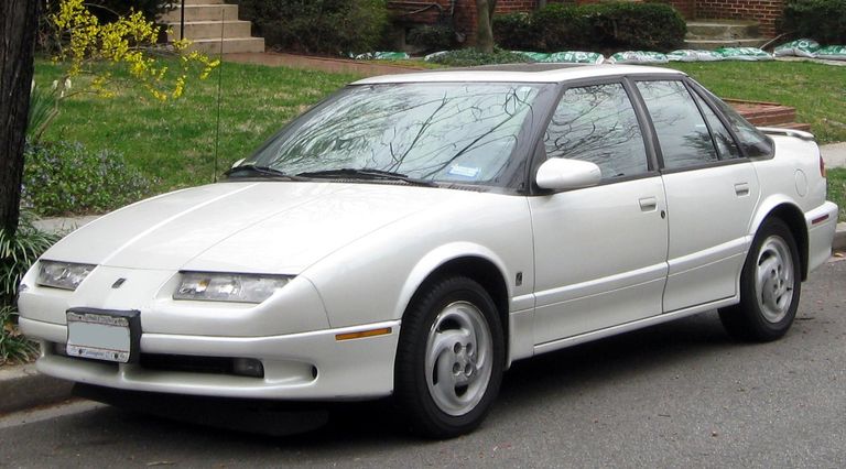
In fact, the car — a white Saturn SL — was 25 years old. This, in retrospect, was the first clue that the contents of the Saturn would solve a 22-year-old cold case.
Leaving without a trace
Fay woke up the next morning at 7:00 a.m. — and the police had disappeared along with the car. Still intrigued, he asked an aunt who lived in the area whether she knew anything about the car in the pond.
The aunt had no idea, and neither did the last owner of Fay's house. “[The previous owner] said sometimes she thought she did see something, but she was never sure,” Fay told The Palm Beach Post. Fay gave up the ghost, assuming it was “just some junked-up old car.”
The cops go to work
Unbeknownst to Fay, though, authorities examined the inside of the Saturn. That’s where they discovered human skeletal remains. Remarkably, a coroner later confirmed that the corpse belonged to a man called William Moldt.
According to the Sheriff’s Office, Moldt was a mortgage broker who'd ventured out to a nightclub in the winter of 1997 — and hadn’t been seen since. His decades-old cold case suddenly got hot again.
The night of
“Never did I believe there would be a 22-year-old dead body [inside the car],” Fay later remarked. According to the missing persons report filed back in 1997, Moldt — who was 40 years old at the time — had “gone to an Adult Night Club” on November 7.
No one said which "Adult Night Club" Moldt had been visiting that night, or whether Moldt had been drinking. Witnesses who'd seen him leave the club reportedly claimed that Moldt hadn’t seemed drunk.
A final message
The missing persons report revealed that at 9:30 p.m. Moldt called his girlfriend to tell her that he “would be home soon.” No one heard from him again. He’d seemingly left the bar before midnight — and vanished.

Police obviously investigated the disappearance at the time, but they came up empty-handed. They considered the possibility that he'd lost control of his vehicle, but a spokesperson told the BBC in 2019 that there had been "no evidence of that occurring."
It was unmistakably Moldt
There were plenty of other details in the missing persons report, though. It revealed Moldt was 6 feet tall and weighed roughly 225 pounds. He had sandy-colored hair and brown eyes.
At the time of his disappearance, he was wearing gray trousers, a white striped shirt, a tie, dress shoes, a Gruen watch, and a very fancy-sounding gold ring. They even recorded his ring size as 13a — but the case was never closed.
Shedding new light on the case
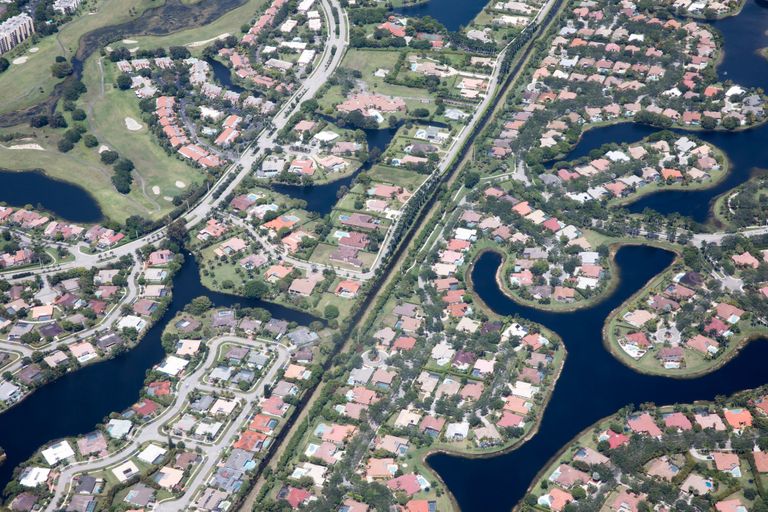
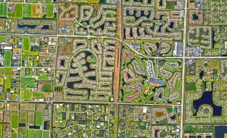
According to reports, construction had been underway in the Wellington, FL, neighborhood at the time of Moldt’s disappearance. The work had apparently been part of the Grand Isles’ Sausalito housing development.
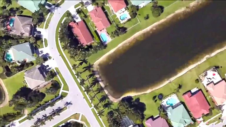
These days, there is a guard rail stopping people from falling or driving into the tear-shaped retention pond. There are also houses built on two sides of the pond. But none of these would have been there when Moldt when missing in 1997.
How did it go unnoticed?
It still seems impossible, though, that nobody noticed a car just beneath the water until 2019. People have been living in the area ever since Moldt went missing, and Google Earth has been around since 2005.
Missing persons cold case website The Charley Project expressed its incredulity: “Amazingly, a vehicle had been plainly visible on a Google Earth satellite photo of the area since 2007, but apparently no one had noticed it.”
A shift in the water
According to Science Alert, however, it may not have been as clear-cut as this. After all, Google Earth constantly updates its images. During its deep dive into the subject, the website found that the car wasn’t visible in the satellite photographs until 2017.
Before then, the images hosted on the platform were apparently too blurry to make out the vehicle definitively. Police spokeswoman Therese Barbera told the BBC that it was a shift in the water that revealed the car.
A mystery remained
The discovery of Moldt's body didn't solve exactly how the car ended up in the water. "You can't determine what happened that many years ago, what transpired," Barbera said. "All we know is that he went missing off the face of the Earth, and now he's been discovered."
As the Florida man behind this story learned, you don’t need a degree in archeology or a hat and whip to call yourself an explorer these days. For proof, look to the countless strange findings that folks have made using Google Earth.
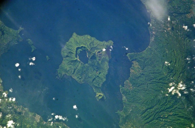
A mysterious mountain
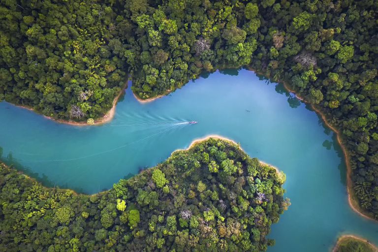
In 2005, for instance, a group of researchers from London’s Kew Royal Botanical Gardens identified a previously undocumented mountain using Google Earth. Mozambique’s mysterious Mount Mabu stretches upwards of 5,600 feet.
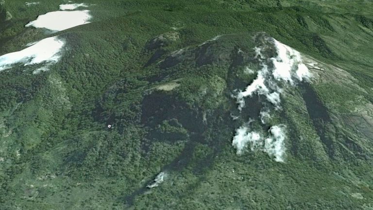
The mountain houses what’s thought to be southern Africa’s biggest medium-altitude rainforest. And yet prior to this phenomenal discovery, scientists — and almost anyone else on Earth — had been completely unaware of it.
Hiding in plain sight
In fact, Mount Mabu had stood largely untouched by people since potentially the dawn of time. Its presence was known only by locals. The peak was entirely hidden by the savannah, which also cut it off from external ecological influence.
This placed it squarely in the sights of conservation biologist Julian Bayliss, who was using Google Earth to search for biodiverse locations in Africa that had yet to be discovered. He certainly hit the jackpot.
A hotbed of new discoveries
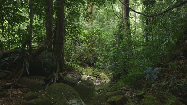
In 2008 a team of 28 researchers — led by plant expert Jonathan Timberlake — headed to Mount Mabu to explore the lost region. In a press release, Timberlake said, “The phenomenal diversity is just mind-boggling...”
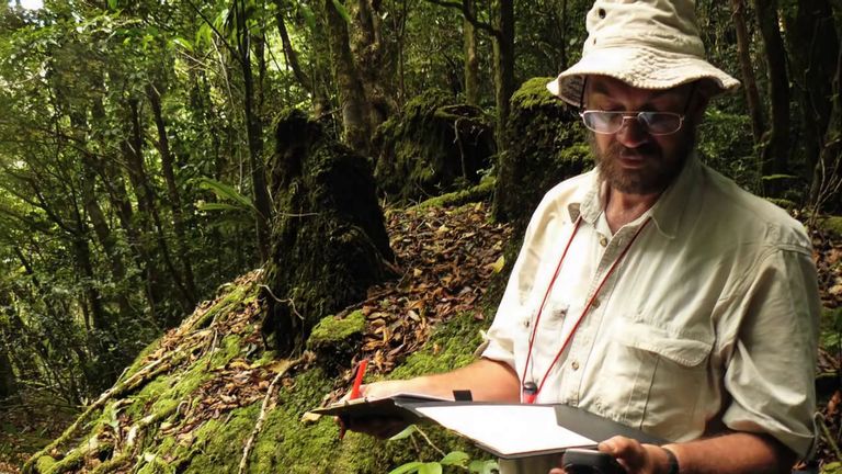
“Even today we cannot say we know all of the world’s key areas for biodiversity; there are still new ones to discover,” he said. All in all, the team collected over 500 specimens of plant life, and they made several new discoveries, too.
"This is the phenomenal thing"
These included Helixanthera schizocalyx, which is a tropical mistletoe, and new snake, butterfly, and crab species. Perhaps none of this would have occurred without Bayliss firing up Google Earth and exploring the unknown.
"Seeing how things are adapted to little niches, to me this is the phenomenal thing," said Timberlake. "If we don't have wonder as a human species, where are we? If we don't have excitement, what are we doing with our lives?"
But Bayliss’s spectacular discovery isn’t the only one that we can credit to Google Earth.
South Africa’s Cradle of Humankind
Back in 2007, Professor Lee Berger of Johannesburg’s Witwatersrand University started using Google Earth to identify the coordinates of 150 caves and fossil locations. Then he happened upon 500 previously unknown sites — and even a ground-breaking pair of skeletons.
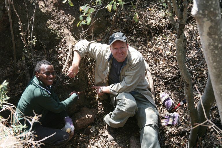
Professor Berger spotted some unexplored caves within South Africa’s Cradle of Humankind. The World Heritage site is a hotspot for hominin relics, with around 40 percent of the fossils of our ancestors coming from there.
Skeletons millions of years old
Sure enough, two more partial skeletons were found in the new cave that Berger had scouted on Google Earth. These aren’t just any old remains, though. According to analysis, they date back to at least 1.78 million years ago.

They are reportedly the most complete example of hominid skeletons ever unearthed. According to Berger, they belong to a new species of hominid, Australopithecus sediba, which is the “most probable ancestor” of modern-day humans.
A 1,000-year-old structure
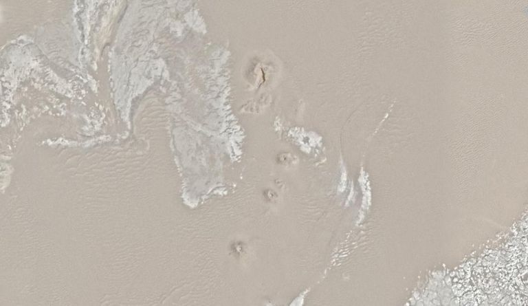
Google Earth has also proved an invaluable tool for researchers even when it hasn’t been the primary driver behind a discovery. In 2009, for example, a pilot spotted an unusual shape in a riverbed in Wales.
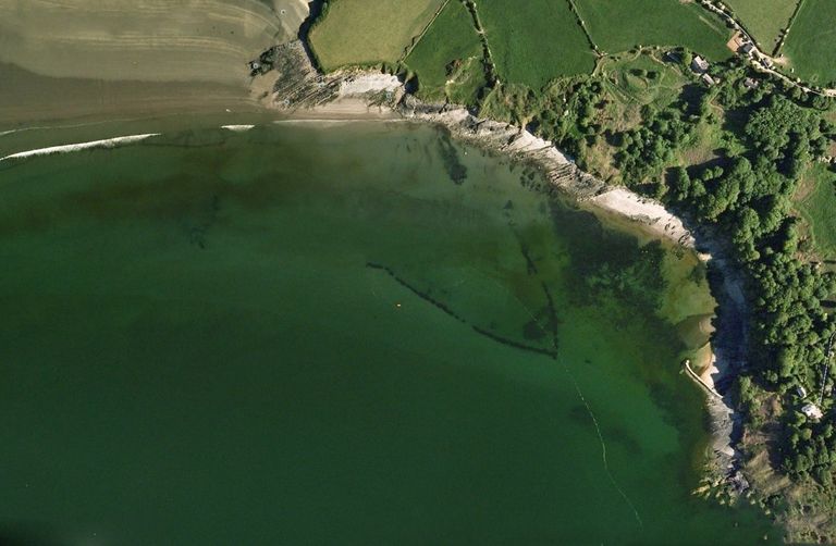
Archeologists then used Google Earth to investigate. By examining the satellite images, they identified a structure that had lain forgotten for potentially more than 1,000 years. The peculiar V-shaped rock formation that the pilot had seen lies in an estuary of the River Teifi.
A millennia-old fishing device
As far as we can tell, it’s entirely man-made. Thanks to Google Earth, experts identified the structure as a millennia-old fishing device. In 2009 Pembrokeshire College marine environment lecturer Dr. Ziggy Otto explained the implications to The Telegraph.
“Its age is unknown, but because of its now entirely sub-tidal position, this fish trap is very old, possibly dating back more than 1,000 years, when the sea level was lower,” he said.
It has transformed over the years
Apparently, this ancient structure would trap fish in the estuary, leaving them behind when the tide went out for fishermen to then scoop up using nets. Remarkably, in the centuries since the device was built, it has naturally transformed into a reef, boosting the area’s biodiversity.

"This fish trap has therefore metamorphosed from an entirely man-made structure to a naturally functioning reef, which adds to the biological diversity not only of the local area but also to that of the Cardigan Bay Special Area of Conservation as a whole," confirmed scientific diver Jen Jones.
Seeing things you've never seen before
Some Google Earth discoveries are less ground-breaking but just as fascinating. If you zoom in on Lake Taal in the Philippines, for instance, you’ll spot one of only two known examples of third-order islands in the world.
In layman’s terms, that’s an island (Vulcan Point) on a lake (Crater Lake) on an island (Volcano Island) on a lake (Lake Taal) on another island (Luzon). Where else are you going to see that?
Take a look for yourself
The only other known instance of this phenomenon was also discovered through satellite imagery. In 2012 Ken Jennings, who is a veteran winner of the game show Jeopardy!, found another – even bigger – example of a third-order island in Canada.
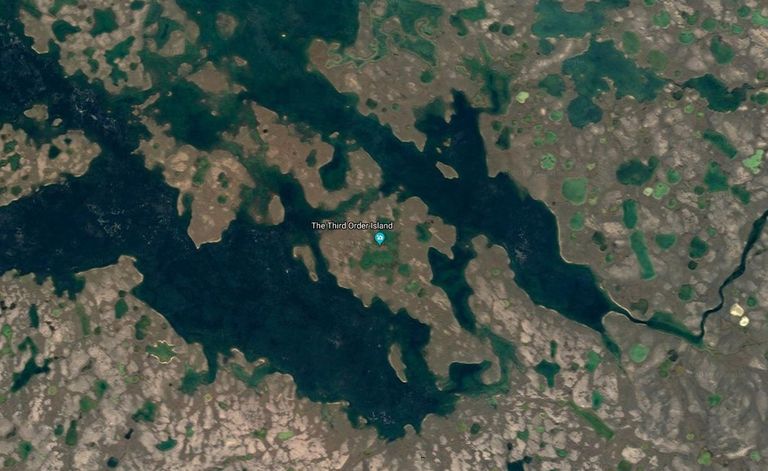
You’ll have to set your Google Earth coordinates to 69.793° N, 108.241° W to see the unnamed island. While the significance of some Google Earth discoveries is clear, others seem to leave us with more questions than answers.
Strange sights
Take Angela Micol’s 2012 find. In a satellite photograph of Egypt, she turned up a pair of strange anomalies that she claimed were undiscovered pyramids. Unfortunately, the socioeconomic state of the country has prevented archeologists from confirming the researcher’s hypothesis, according to Live Science.
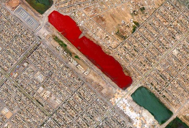
In fact, there are plenty of oddities on Google Earth that you can check out for yourself. If you head to the coordinates 33.396157° N, 44.486926° E, you’ll spot something strange in the terrain.
Seeing red
That’s because the map reveals what appears to be a blood-red lake situated in Iran close to its border with Turkey. And for a while, the water’s mysterious color seemingly had no explanation.
It eventually transpired that Lake Urmia — at one time, one of the Middle East’s largest lakes — had shifted from its regular green tint sometime between April and July 2016. The culprit was not a Biblical plague, but instead a type of bacteria.