Experts Uncovered A Giant 2,300-Year-Old Structure In The Desert, And It’s Causing Quite A Stir
Thirteen imposing stone towers. Two observation platforms. One temple with a mysterious purpose. And defensive walls to ward off unwanted guests… We’re talking about the archaeological site at Chankillo in Peru, which baffled experts for more than 100 years. Their first thought was that the awe-inspiring complex was a place for cult rituals, but when they finally uncovered the truth, they realized they couldn’t have been more wrong.
As old as time
It’s even more mind-blowing when you consider the Chankillo complex was constructed about 2,300 years ago. Modern-day people have also been aware of the incredible stone towers since at least the 19th century. But it actually took a 21st-century study to finally figure out their actual purpose.
Research in ruins
“It seems extraordinary that nobody really recognized [the towers] for what they were for so long,” the University of Leicester’s Professor Clive Ruggles told the BBC in 2007. That’s particularly strange when you consider just how impressive the site is. “I was gobsmacked when I saw them for the first time,” Ruggles added. And he wouldn’t have been alone.
Towering achievement
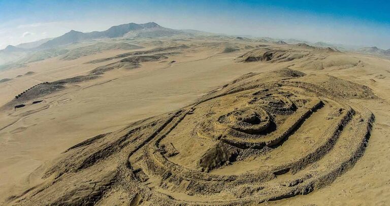
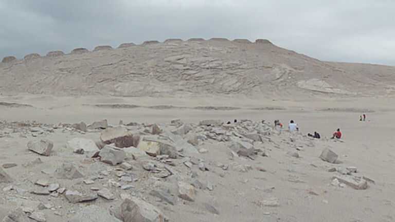
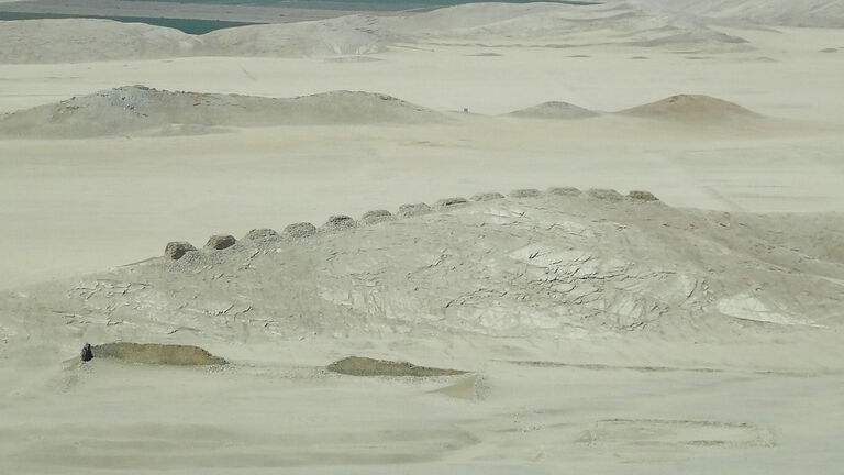
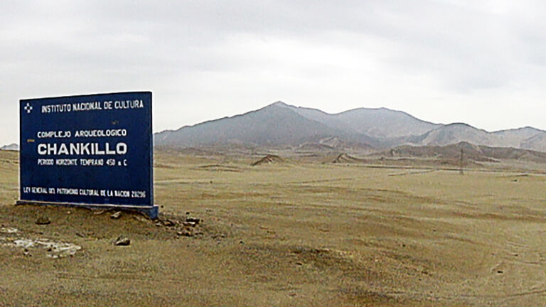
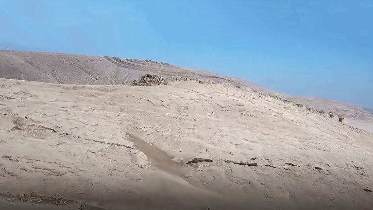
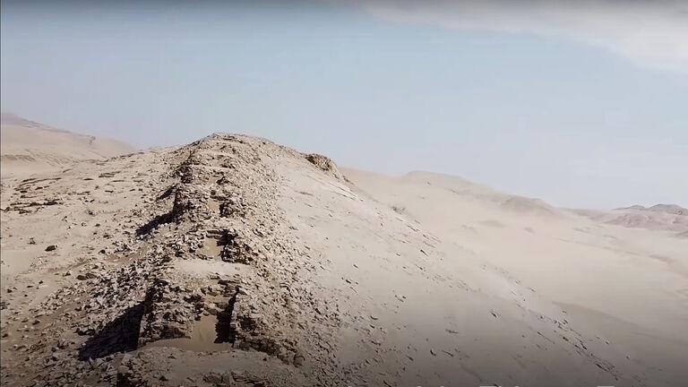
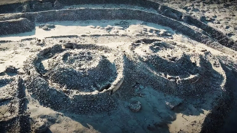
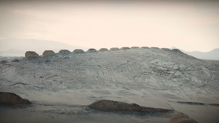
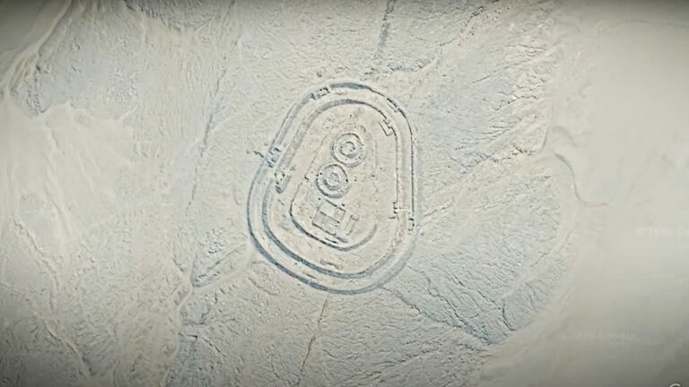
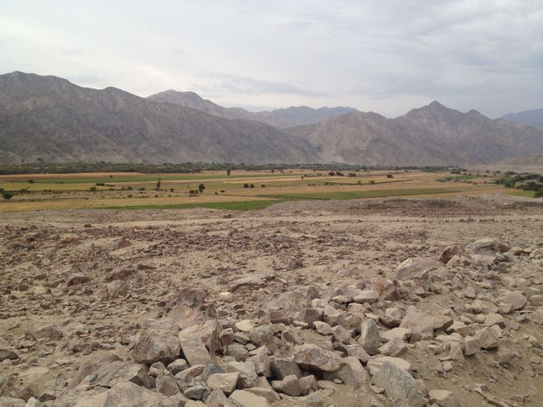
The Chankillo complex is found in the desert of the Casma Valley on the coast of Peru. To give you a sense of its extraordinary size, it occupies a massive 1.5 square miles of land — that’s about 726 football fields. And those perplexing 13 towers are of considerable bulk, too.
13 Towers
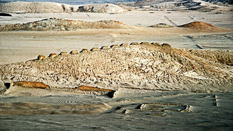
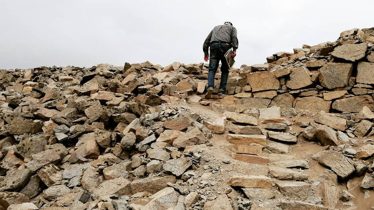
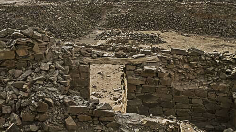
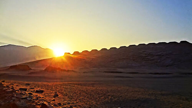
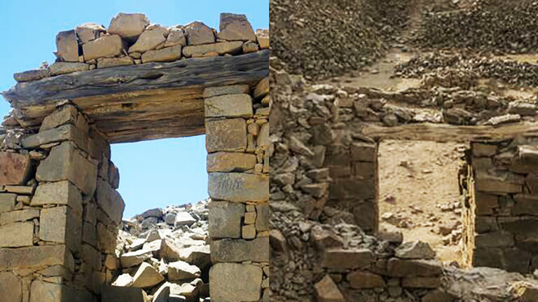
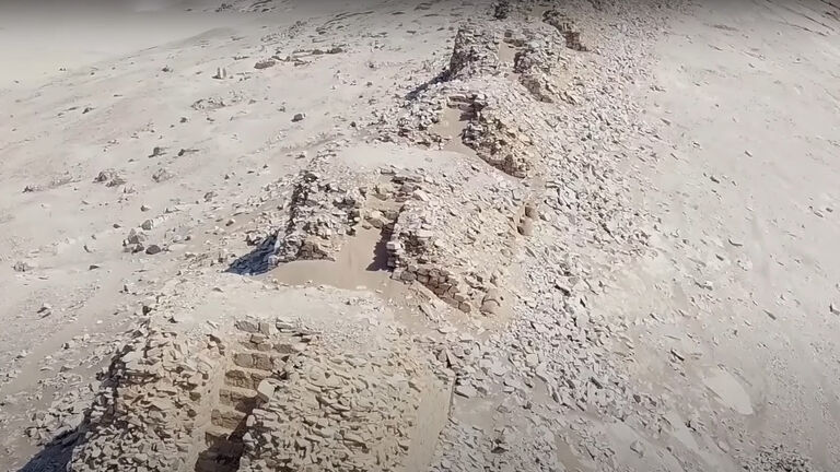
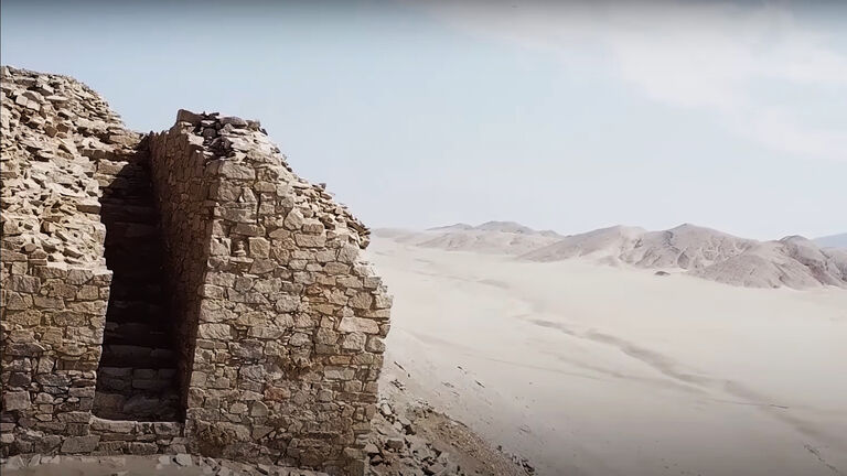
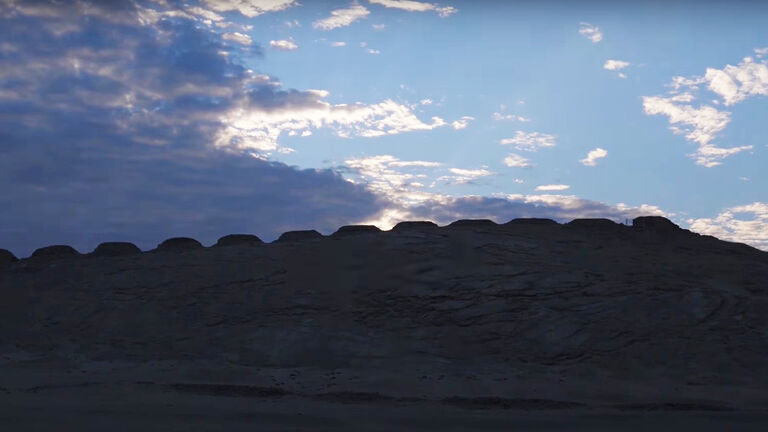
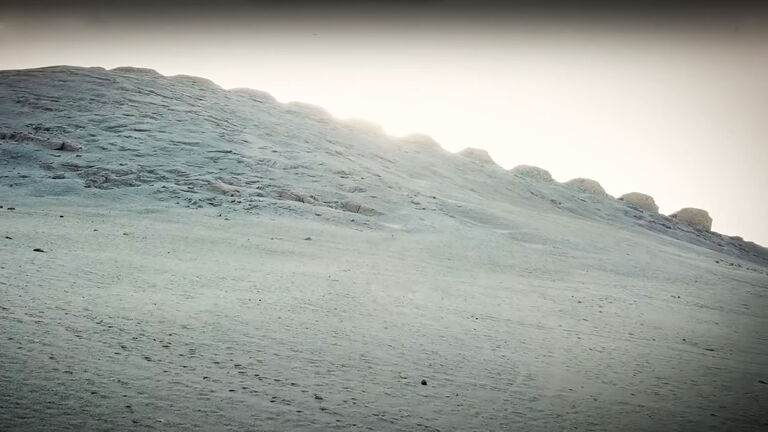
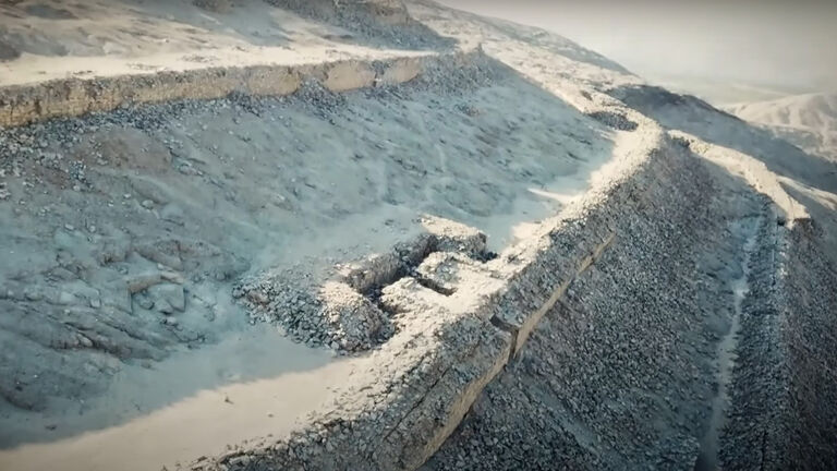
The towers are on the crest of a small hill in Chankillo. They’re all rectangular and stand between 6 and 20 feet tall. And even though they’re thousands of years old, they’re still in pretty good shape. But it’s the way the towers are arranged and accessed that makes them so interesting.

Top of the tower
If you look carefully, you’ll see that the towers are organized from north to south across the ridge. There are evenly spaced gaps between each of them, too. This creates a striking serrated view that offers a clue to the site’s previously unknown purpose. And there’s even an easy way for you to scale to the top.

Secret stairs
Yep, each tower has two staircases carved into it. You could walk these steps to the top of the tower, and you’d probably enjoy a mighty fine view if you did. But giving people a better look at the horizon is not the reason why the towers exist.
Battle fort
As we mentioned, Chankillo first came to people’s attention in the 1800s. And in the time since, there have been plenty of theories about why the site was there. It was thought, for example, that the complex had been a place for ritual battles or fighting. There was a lot of circumstantial evidence to support this, too.

Defensive positions
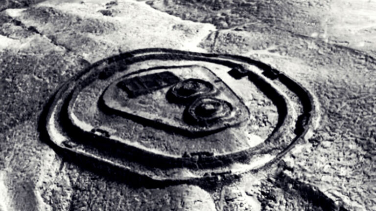
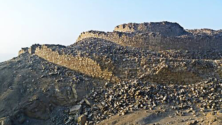
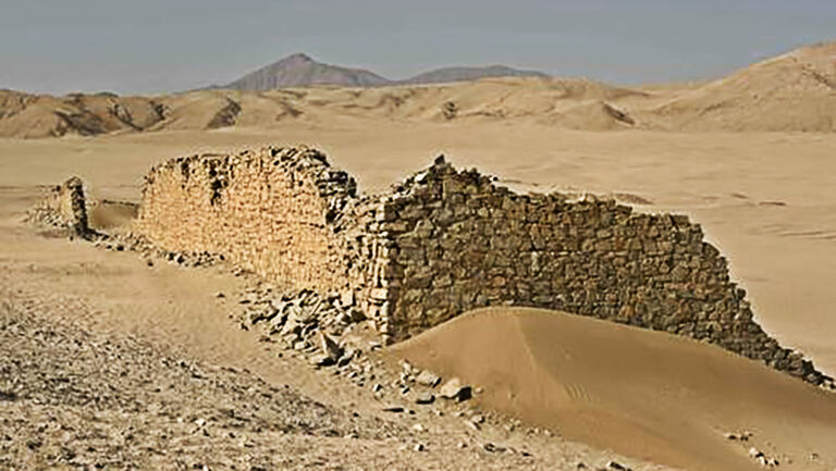
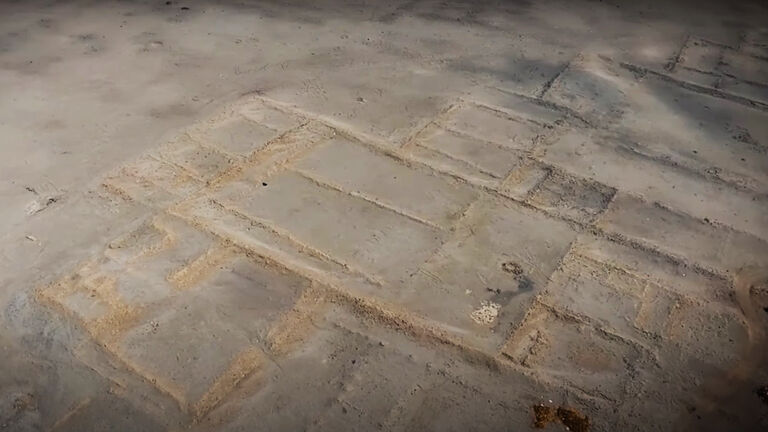
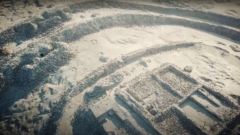
First off, the site is made up of three buildings. These buildings are each surrounded by walls that stretch up to 20 feet high. So while archaeologists may not have known why the buildings were constructed, the layout of the area gave off strong fortress vibes. And it wasn’t just those ringed walls that did it.

Solid battlement
Think about it. You’ve got large, solid walls surrounding three buildings. There are stone towers to one side. The site is also positioned on a ridge above the landscape. All of these things combined would make Chankillo pretty easy to defend against potential attacks. And at the time the towers were built, repelling enemies could have been a big consideration.
Early Horizon
That time — roughly 400 B.C. — is known as the Early Horizon period. And there are multiple areas around Chankillo that prove people did build impressive fortifications back then. It goes to show just how rife with conflict this part of Peru was. But something about Chankillo just didn’t add up...

Open sesame
The thing confusing archaeologists was that Chankillo couldn’t have operated as a normal fort — if it was a fort at all. A glance at its three buildings revealed to the experts that they would be easily penetrable by invading forces. The solid construction evidently had some serious flaws.

Coming and going
Remember the three high walls surrounding the buildings? They actually had multiple entrances. The first one had five places through which to come and go, the second wall had four entrances, and the final one had three. That’s hardly ideal if your ultimate goal is to keep people out of the buildings!

A new theory
So perhaps the idea of Chankillo being some kind of impenetrable fortress was a little far-fetched. And that’s why the experts came up with a new theory about the purpose of this complex. The first spark of the next idea seemingly came about when folks realized that the buildings had been maintained surprisingly well.
Clean report
It seems that this didn’t occur to anybody until the turn of the 21st century, though. Up to that point, no one had really bothered to give Chankillo a thorough investigation. This all changed in 2001, when finally someone decided to take a closer look. But what did it mean that the insides of the buildings were strikingly clean?
Rituals
The experts thought that this aligned with what they’d seen in other structures built by cults. This led archaeologists to believe that Chankillo actually had a temple at its heart. It also meant that there had been some kind of ritualistic behavior happening on site. The problem? Nobody knew what this “cult” had been worshipping.
Unknown people
Then, in 2013, Professor Brian Cox visited Chankillo for his BBC show Wonders of the Universe. And the physicist described the people who built Chankillo 2,300 years ago as “a civilization we know almost nothing about.” But if researchers know very little about a group of people, how could they figure out why they built these buildings?
No trace
“The details of this culture and all traces of its language are lost,” Professor Cox continued. So anybody who’d been trying to research Chankillo had nothing but the buildings and structures themselves to interpret. There was simply no way of telling who’d built them. Luckily, though, the buildings did offer some clues.
All white
“Its walls were once brilliant white and covered with painted figures,” according to Professor Cox. The experts could tell this, Cox said, even though “all but the smallest fragments of decorations are gone.” All the same, what had been left behind — combined with other details around the site — gave experts the evidence they needed to get to the truth.

New research
“If you stand in the right place, you can still experience the true purpose of Chankillo, just as you could the day it was built,” Professor Cox said in Wonders of the Universe. But of course, he could state this confidently in 2013 — because two other experts had already published their definitive findings about the complex.
The science part
Dr. Ivan Ghezzi and Professor Ruggles were the men behind the report, which was published in the journal Science in 2007. Dr. Ghezzi had been studying for his doctorate in anthropology at Yale at the time of his discovery, and he had only been at Chankillo because he’d been studying fortresses. But then he realized that something didn’t make sense.

New discovery
Dr. Ghezzi’s initial study actually took place back in 2001. Before this, you’ll remember, people generally thought Chankillo had been a fort. Yet no one had come up with a satisfying explanation for the existence of the 13 towers. That all changed after the grad student began working at the site.
Breaking ground
“Since the 19th century, there was speculation that the 13-tower array could be solar or lunar demarcation — but no one followed up on it,” Dr. Ghezzi told Yale News in 2007. But the researcher spotted an opportunity, and he had the support of those around him. “So we said, ‘Let’s study it while we are here!’” the academic explained.

Fast action
It didn’t take long for Dr. Ghezzi’s instincts to turn up surprising results. “In the first hours of measurements, we realized the nature and importance of the towers,” the academic told The New York Times in 2007. And while it would take six more years to get the final paper fit to publish, Dr. Ghezzi was positive of what he’d found.

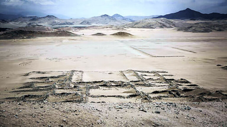
Solar calendar
Dr. Ghezzi focused his attention on two points found within those sturdy walls and buildings we mentioned earlier. These points are about 750 feet away from the 13 towers and situated to their east and west. And after the researcher took his first measurements, it became clear that these were observation areas of great importance.

Look out
But what had the ancient civilization who lived here been observing? According to Dr. Ghezzi’s research, the positions of the 13 towers aligned almost perfectly with where the Sun would rise and set over the course of a year. That couldn’t be a coincidence, and it convinced the academic that the towers were there to observe the passing of the seasons.

Rise and fall
Here’s how it works. Let’s imagine you’re standing on the observation point to the towers’ west side. And as you stand there, first thing in the morning, the Sun begins to rise above the horizon. Now all you have to do is make a note of where the Sun pops up in relation to the towers. Easy, right?
Calendar men
Well, easy and kind of ingenious. You see, the position of the Sun as seen from the observation point will then tell you what time of year it is. There were no smartphones in 400 B.C., remember. So if the Sun appeared at the furthest right-hand point of the towers, that would mean it’s the summer solstice in Peru.
Winter winner
And if the Sun popped up at the opposite end of the towers, then you’d know it was the winter solstice. For the rest of the year, too, the Sun would rise at various points along the towers. So the 13 towers are, effectively, one big calendar. This revelation was groundbreaking for a number of reasons.
Big news
It meant that the Chankillo solar observatory was the earliest example of this kind of structure we’ve ever found. And not only that, but it’s also different from other solar observatories because it could tell the time throughout an entire year. “Archaeological research in Peru is constantly pushing back the origins of civilization in the Americas,” Dr. Ghezzi told Yale News.
Early man
Dr. Ghezzi also revealed that Chankillo is older than observatories found in Europe by about 1,800 years. It’s also roughly 500 years older than any similar building made by the Mayans. So while the experts may have known about similar ways our ancestors kept time, they had no idea just how long ago it had all started.
Reap what you sow
Why did people do this? Well, it would’ve definitely helped civilizations to know when to plant various seeds and crops throughout the year. It would also allow them to pinpoint when exactly to honor any religious festivals that align with the seasons. But the researchers also realized that it could have had another purpose.
Power of the Sun
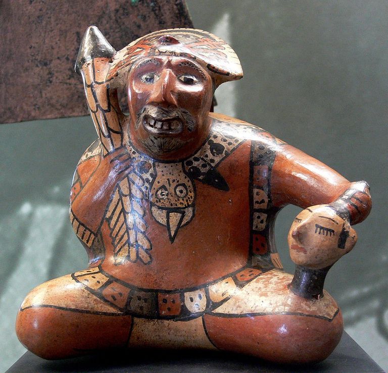
The experts knew about the Inca king who explicitly used the Sun to help make political decisions. He did this, apparently, because he thought of the Sun as a deity — and himself as a direct descendant of it. And considering the Incan Empire came much, much later than the Chankillo observatory, this could shed new light on the earlier complex.
Sun gods
Dr. Ghezzi and Professor Ruggles believe that the 13 towers could have been a pointed message to those who lived in the area. Basically, whoever owned or operated the towers was in charge of everybody else. So perhaps it was almost like they were saying, “I control the Sun!” At the time, that would have been an intimidating show of power.
Revelatory
And, today, the site holds the same power as it once did. Even a seasoned researcher such as Professor Ruggles was won over by Chankillo’s impressive stature. “I am used to being disappointed when visiting places people claim to be ancient astronomical observatories,” the scientist told Yale News. But Chankillo was an altogether different story.
Extraordinary power
“Chankillo is one of the most exciting archaeoastronomical sites I have come across,” Professor Ruggles continued. He also found it hard to believe that the solar observatory had not been discovered many years before. But now we know what the structure is, we can begin to understand the lives of these long-lost people.
Power play
Professor Ruggles explained to the BBC that the size of the observation points raises an interesting issue. The expert said the point to the west of the towers could not have been very big. At most, he thought, only three people could have watched the sunrise from here at any one time. And this tells us something very important.
Ritualistic
“All the evidence suggests that there was a formal or ceremonial approach to that point and that there were special rituals going on there,” Professor Ruggles said. So that means that not just anybody could have wandered up to the observation point and noted the time of the year. That job would probably have been left to someone very powerful in the civilization.
Stand on ceremony
Professor Ruggles told the BBC that it was likely a priest “who watched the Sun rise or set, while in the plaza next door the crowds were feasting.” So even though the ceremonial crowds could’ve seen the Sun, they wouldn’t have witnessed its rise from that all-important vantage point. And access to that special spot was the true expression of ancient power.
Modern musing
You can still experience some of that power today. After all, the Sun rises and sets in pretty much the same way today as it did 2,300 years ago. So if you ever find yourself in the deserts of Peru without your Apple Watch, you’ll know exactly how to tell what time of year it is! And if you hover above the desert, you may just find something incredible.
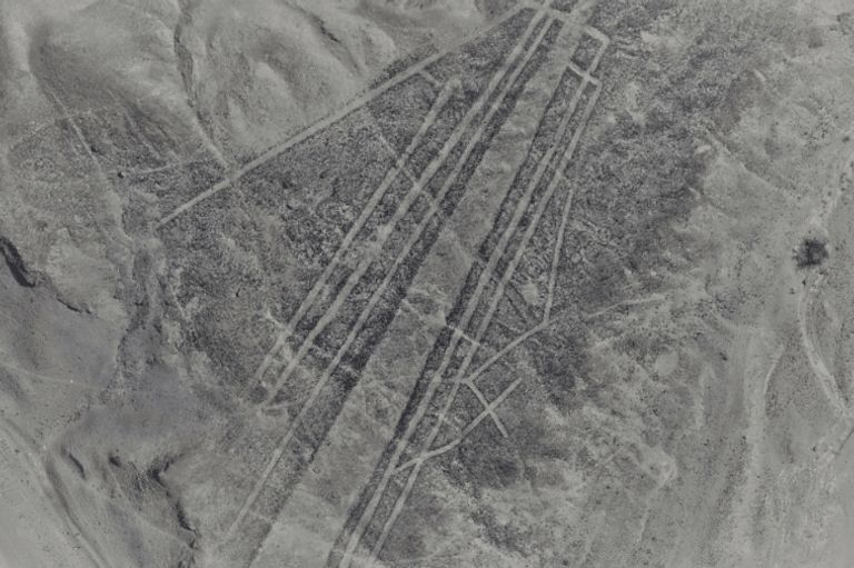
Strange carvings
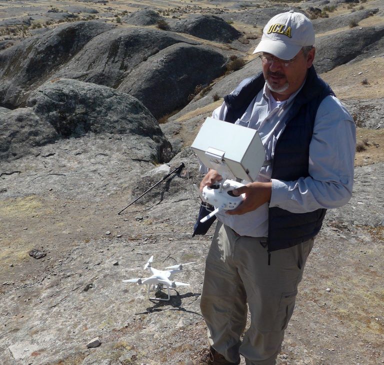
Almost 100 feet above the sand, drones captured aerial footage of the ground below. And when archaeologists studied the resulting images, they discovered something that they weren’t expecting: traces of ancient geoglyphs carved into the rock many centuries ago. But what are these mysterious etchings? And what do they mean?
The Nazca
First emerging around 100 B.C., the Nazca were a people who once flourished in the south of Peru. Native to the valleys of the Ica River and the Rio Grande de Nazca, they were known for their advanced artistic and technological skills. And even today, long after their culture has disappeared, they are remembered in the place names of their former homeland.
Sophisticated people
According to experts, the Nazca were an agricultural society that entertained strange practices such as cranial manipulation – a technique used to deform a young child’s skull. They were nonetheless also considered sophisticated for their time. In fact, they constructed an aqueduct system that is still utilized today.
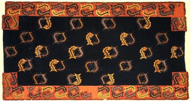
Incredible artworks
Additionally, the Nazca forged beautiful pottery and wove complex, intricate textile patterns. But it was their fascinating geoglyphs that would ensure them a place in history for centuries to come. Even though their civilization had disappeared come 750 A.D., these incredible artworks still remained etched on the landscape for all to see.
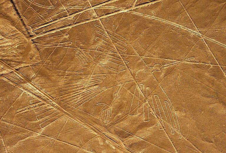
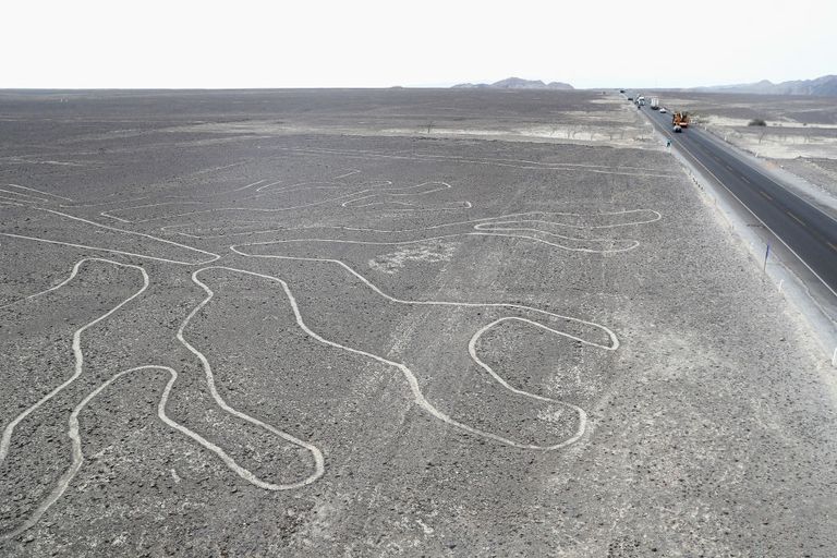
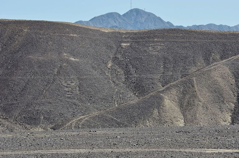
The Nazca Lines
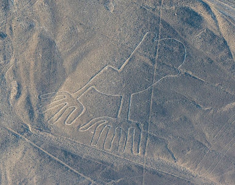
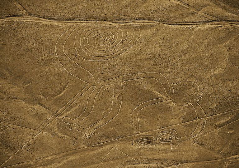
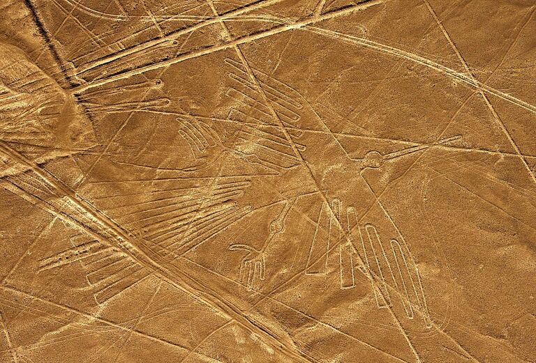
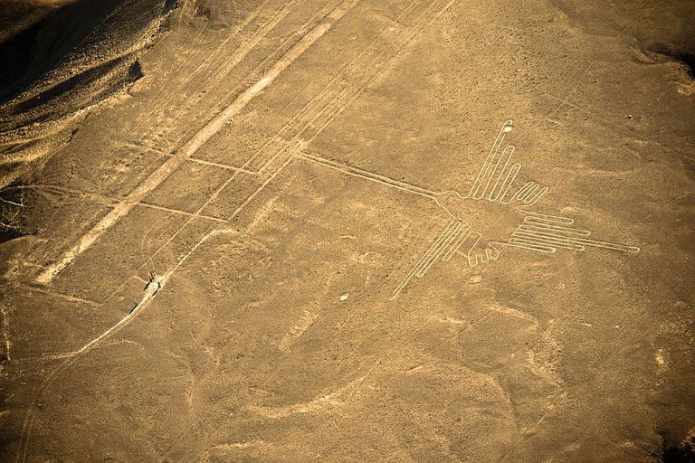
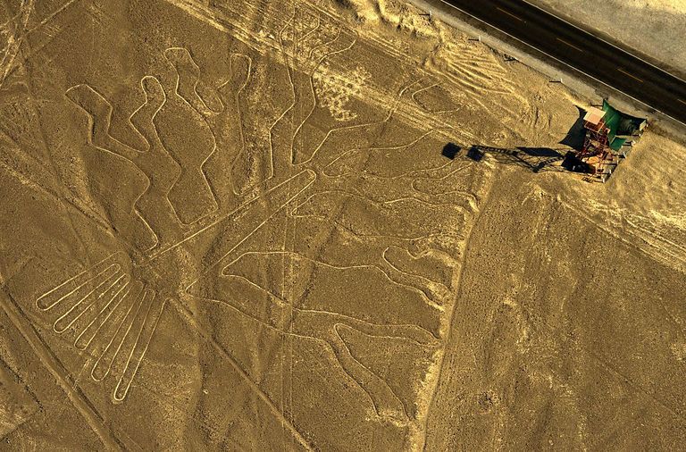
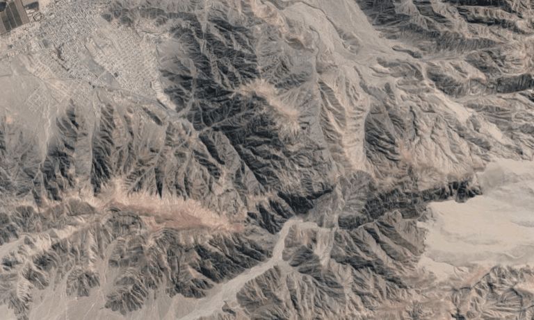
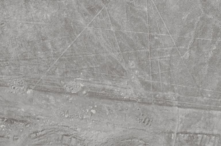
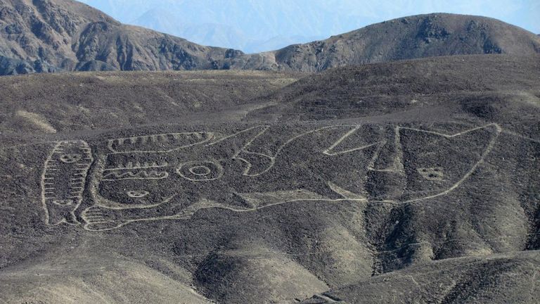
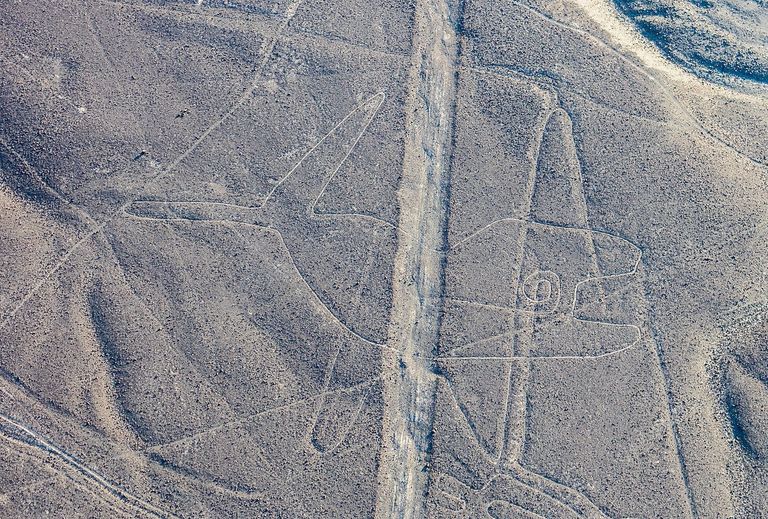
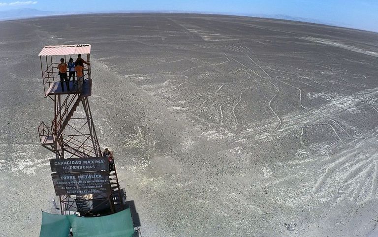
Today, the floor of Peru’s Nazca Desert is crisscrossed with hundreds of markings known as the Nazca Lines. Covering almost 20 square miles, these designs were formed by carving shallow depressions into the ground. And while some take the form of seemingly endless lines stretching across the landscape, others are more awe-inspiring in nature.
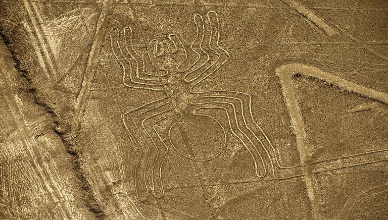
A hummingbird, a monkey, and even a jaguar
Among the figures formed by the Nazca Lines are over 70 depictions of animals, including a hummingbird, a monkey, a dog, a lizard and a jaguar. Other patterns, meanwhile, are arranged to show various flowers and trees. However, these detailed images aren’t immediately visible to those who visit the Nazca Desert – for one deeply mysterious reason.
Why were they created?
Bizarrely, the intricate designs of the Nazca Lines cannot be fully appreciated unless viewed from the air. And although some of the patterns can be seen from higher ground in the region, their nature has led many to speculate about whom they were created for. Did the ancient people of Peru master flight long before the Wright brothers took to the skies, or was something even stranger at play?
The likely theories
According to most experts, the Nazca Lines were likely constructed for religious or ceremonial reasons. Some believe that they were designed to be viewed by gods in the heavens, while others suspect that they were constructed to align with the stars above. Interestingly, this latter technique can be seen elsewhere, such as the ancient monument of Stonehenge in Southern England.
Captivating visitors
Others, meanwhile, have dismissed these more elaborate explanations, claiming instead that many of the patterns are simply ancient irrigation channels. But whatever the truth behind the Nazca Lines, there’s no doubt that their mysteries have captivated visitors to the Peruvian desert for generations.
Landing strips for aliens?
In fact, some have even gone so far as to suggest that the Nazca Lines offer proof of alien life. And in the 1960s, some radical theories emerged alleging that the designs were actually landing strips created to guide extraterrestrial visitors to planet Earth. Unsurprisingly, however, no evidence has emerged to support such claims.
Fragile lines
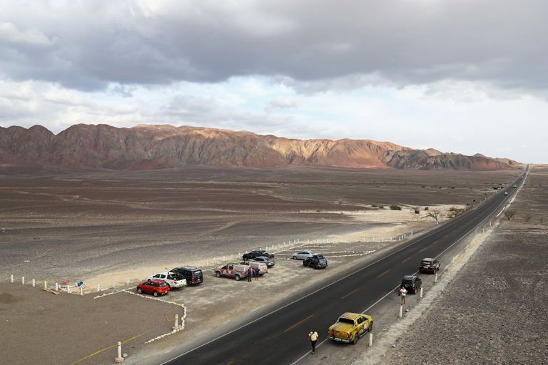
Today, the Nazca Lines remain a popular tourist attraction in Peru, drawing many thousands of visitors annually. The lines are also considered fragile, however, and as a result the location has been designated a UNESCO World Heritage Site. Unfortunately, though, this status hasn’t always been enough to ensure its protection.
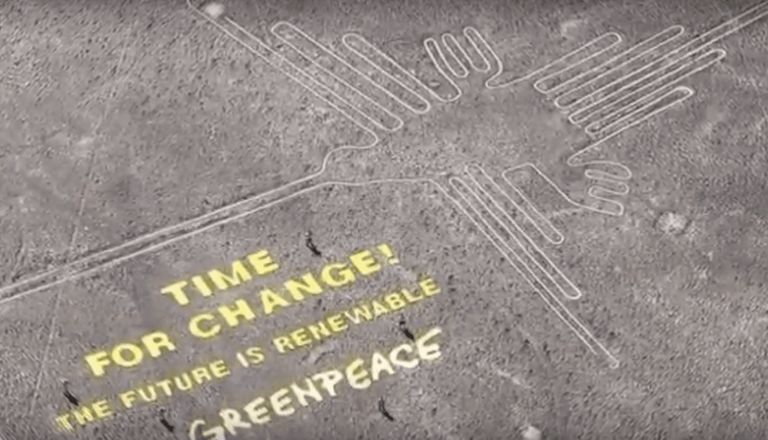
The Greenpeace controversy
In 2014 controversy gripped the region when a group of Greenpeace activists staged a protest close to the Nazca Lines. They unfurled a banner promoting renewable energy on the site – and allegedly caused damage to the geoglyphs at the same time. And while the charity claimed that its representatives had acted responsibly, others accused them of trespassing on a protected location.
Damage done
With the eyes of the world again turned on the fragile Nazca Lines, it soon came to light that a considerable amount of damage had been caused to the site over the years. In fact, it appeared as if everyone from squatters to participants in the famous Dakar Rally had left their mark on the geoglyphs. Keen to prevent further destruction from occurring, the United States government subsequently stepped in to fund restoration work.
The man in the know
With the support of the U.S., the Peruvian authorities were able to hire Johny Isla, an archaeologist who has been studying the Nazca Lines since the 1990s. Together with the German Archaeological Institute’s Markus Reindel, Isla has spent decades attempting to document the fascinating geoglyphs of the Nazca Desert.
Still much to find
According to Isla’s colleague Luis Jaime Castillo Butters, archaeology in Peru is tough work. And out of some 100,000 locations of interest across the country, just 5,000 or so have been adequately studied on-site. Moreover, an even smaller number have been subjected to the sort of aerial observation that could reveal sights such as the Nazca Lines.
A step in the right direction
Then, in 2017 all this changed. That year, Isla and Castillo were successful in commencing a partnership with the GlobalXplorer initiative. Founded by University of Alabama at Birmingham archaeologist Sarah Parcak, the project saw her pick up a coveted prize from the team behind TED Talks in 2016.
Volunteer helpers
With GlobalXplorer, Parcak aims to crowdsource archaeology. Through the project, trained volunteers are invited to become citizen scientists and try their hand at analyzing a collection of satellite images. Afterwards, they are instructed to flag up any signs of possible looting, as well as archaeological sites that might still be unknown to the wider world.
"A 21st-century army of global explorers”
“I wish for us to discover the millions of unknown archaeological sites across the globe,” Parcak wrote on the TED website in 2016. “By building an online citizen science program and training a 21st-century army of global explorers, we’ll find and protect the world’s hidden heritage, which contains clues to humankind’s collective resilience and creativity.”

The obvious choice
With the TED prize victory under her belt, Parcak was finally able to launch her visionary approach. And in Isla and Castillo’s work, she found the perfect match. “When we were thinking about countries to go to… it had to be a country that everyone in the world would know is important, where the Ministry of Culture would be open to new technology, and where most of the sites would be out in the open and fairly easy to detect,” she told National Geographic in 2018. “Peru definitely fit the bill.
A new find?
So with the location having been settled upon, GlobalXplorer’s first project launched. It asked volunteers to study satellite images of the Peruvian landscape. Amazingly, the project’s technology enabled these people to spot objects just a foot across that had been photographed from a distance of almost 400 miles. And when something of potential interest was identified, the experts were then sent in to take a closer look.

Finding the truth
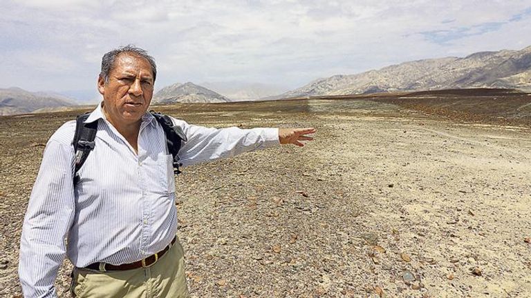
In December 2017 Castillo traveled to Nazca and the neighboring province of Palpa along with some students. And with support from both National Geographic and Peru’s Sustainable Preservation Initiative, they began carrying out what’s known as a “ground-truthing” mission – an attempt to verify the satellite findings from a closer perspective.
Some bad news
Upon their arrival in the region, however, initially Castillo and his team didn’t discover much in the way of new activity or hidden archaeological treasures. In fact, the looting locations that they were directed to turned out to be many years old. They also found damage caused by illicit mining activity in the area.
Something staggering is revealed
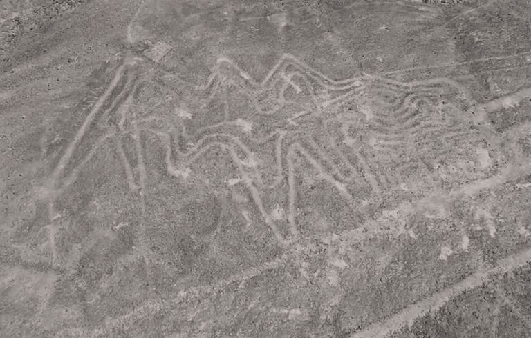
The team subsequently decided to bring in drones for a closer look – and that’s when things became interesting. Unlike the satellites used by GlobalXplorer, these airborne cameras are capable of spotting features on the ground that are under half an inch across. And with this more precise technology, something staggering was revealed.

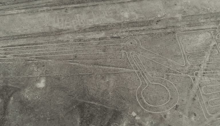
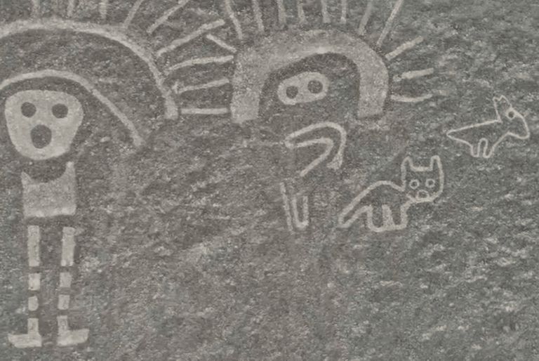
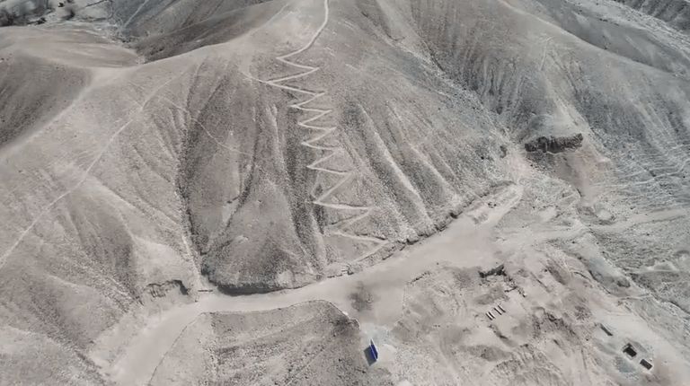
More geoglyphs!
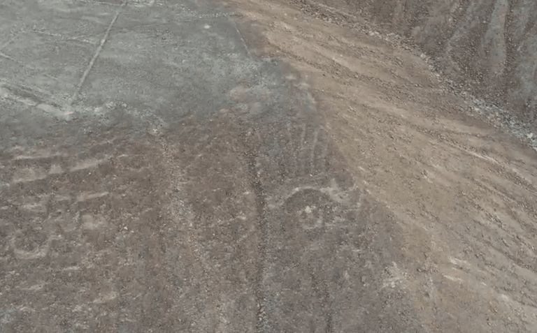
Amazingly, the drone cameras returned images of more than 50 hitherto unseen geoglyphs stretching across the desert. And unlike the Nazca Lines, these designs had been etched into sloping ground, making the patterns visible to those living below. However, they had been worn away over the years until just the merest traces remained.
Better than the Nazca Lines
While some of the Palpa geoglyphs appear to have been previously noted, their faint nature meant that they were often perceived as little more than simple marks. Thanks to the work of high-resolution drones, though, the geoglyphs’ true nature has finally been revealed. And among them are some incredible designs that put even the Nazca Lines to shame.
A huge pelican
Moreover, while some of the designs had previously remained very faint from an aerial perspective, many of them became startlingly clear in the drone images. For example, the new footage clearly shows the shape of a tupu, a type of clothing pin, carved into the desert floor. Elsewhere, the stylized image of a pelican can be seen, its lines covering an incredible distance of almost 500 feet.
A bizarre dance
Interestingly, one of the strangest designs appears to show a human figure attached to an ape. While some experts believe that the figure is that of a dancing female, others have described it as a person flying through the air. And bizarrely, some commenters on YouTube have taken this to be ancient evidence of extraterrestrial life.
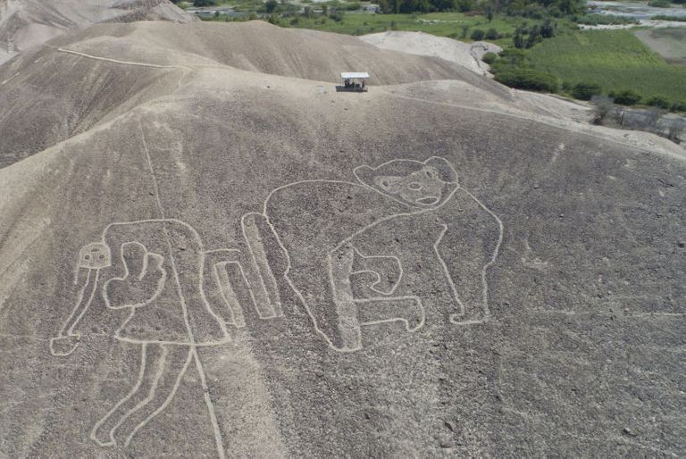
Warriors
In fact, many of the Palpa designs appear to depict humans – unlike the Nazca Lines, which largely show animals and geometric patterns. “Most of these figures are warriors,” Castillo told National Geographic. “These ones could be spotted from a certain distance, so people had seen them, but over time, they were completely erased.”
The people responsible
But who exactly was responsible for etching these incredible designs into the desert floor? According to experts, it was a culture even older than the one responsible for the Nazca Lines. In fact, they believe that these geoglyphs were created by the Nazca’s predecessors, the Topará and the Paracas, as early as 500 B.C.
The Paracas
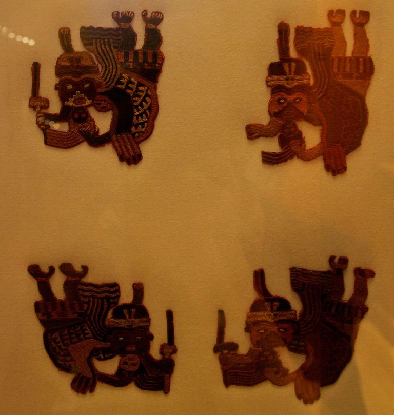
First emerging around 800 B.C., the Paracas culture thrived in the Andes mountains of Peru until around 100 B.C. Like the Nazca after them, they are known to have developed advanced skills in the field of water management. Moreover, sophisticated ceramics and textiles have also been recovered from Paracas sites.

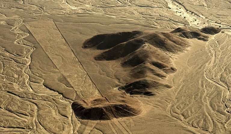
Are they road signs?
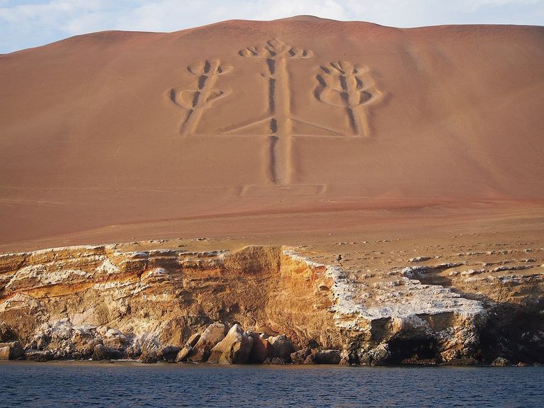
In the 1920s Julio Tello, a pioneering archaeologist from Peru, began excavating in a region known as the Paracas Peninsula. And from his discoveries, he was able to paint a picture of how these ancient people lived thousands of years ago. Interestingly, experts believe that they may have used geoglyphs like the famous Paracas Candelabra as a type of road sign, indicating the location of trading points.
Societies with much in common
Around half a century before the Paracas are thought to have disappeared from Southern Peru, a culture known as the Topará arrived in the region. And while little is known about these northern interlopers, it’s understood that both groups lived uneasily side by side for a number of years. Despite their differences, though, experts believe that the two societies had many common customs and skills.
Even older geoglyphs
According to some historians, the Nazca culture eventually developed from both the Paracas and the Topará peoples. In fact, it’s thought that some of the oldest Nazca Lines were actually created by these earlier groups. Most of the geoglyphs at Palpa, however, are understood to be centuries older than their more famous counterparts.
Before the Paracas
Furthermore, it’s claimed that a number of the patterns might have been created by a culture that existed prior to the Paracas, although there’s no clear indication as to who that might have been. Experts have expressed excitement, meanwhile, over the age of the geoglyphs and what that might indicate for the future of archaeology in the region.
Keeping them safe
“This means that it is a tradition of over a thousand years that precedes the famous geoglyphs of the Nazca culture, which opens the door to new hypotheses about its function and meaning,” Isla told National Geographic. Identifying the lines was only the first step, though. Now, archaeologists must work to ensure that these discoveries are adequately safeguarded.
Protective measures
Thankfully, the Palpa geoglyphs are located within the UNESCO World Heritage Site that’s already established around the Nazca Lines. As previous incidents with rally drivers have shown, however, this doesn’t always guarantee protection. Furthermore, these latest discoveries still haven’t been registered with the Peruvian government.
More data
While Castillo’s team works towards having the new geoglyphs officially recognized, GlobalXplorer volunteers are bringing even more data to the table. Since the Palpa discovery, in fact, they’ve identified a large number of other sites of interest. Archaeologists are currently busy following up on these leads.

A lot of info
“The data and information obtained with the GlobalXplorer project are extraordinary in quality and quantity, and above all in a relatively short period of time,” Isla explained, describing the initiative that led them to their discovery. “This puts us at the forefront in the registry of archaeological sites and geoglyphs in particular.”
Priceless archaeological heritage
Moving forwards, both Castillo and Parcak hope that GlobalXplorer will help protect locations such as Palpa from one of the biggest threats that they face: urbanization. Peru is apparently rife with unauthorized building projects, some of which infringe on the nation’s priceless archaeological heritage.
“We’re fighting an army of lawyers”
“We’re not fighting a looter with his shovel, running away when you’re blowing a whistle; we’re fighting an army of lawyers,” Castillo explained. “This is a constant battle, so the work we’re doing – documenting the sites, georeferencing – is the best protection we can give the sites.”

.jpg)